

National Route 339, commonly known as the Tatsudomari Line, which runs through the Tsugaru Peninsula, is one of the most attractive routes for touring enthusiasts from all over Japan.
This article provides an overview of the Tatsudomari Line and explores why so many motorcycle riders visit this place.
Overview and characteristics of the Tatsudomari Line
The Tatsudomari Line is a approximately 20km course that continues to Tappimisaki, the farthest point of the Tsugaru Peninsula.
It is becoming increasingly popular among touring enthusiasts due to its beautiful scenery and easy-to-ride roads.
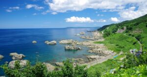
In the Goshogawara City area in the south, there are exhilarating roads overlooking the majestic Mt. Iwaki.
In the northern Tappimisaki area, you can enjoy winding roads and beautiful scenery.
The most distinctive feature is the change in the location of the Tatsudomari Line.
The spectacular scenery of the coastal road along the Sea of Japan changes to a winding road through the mountains.
A course that combines these two characteristics is the appeal of the Tatsudomari Line.
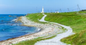
The length of the Tatsudomari Line is short, so you can run through it in less than 30 minutes, but the varied scenery is highly satisfying, and the final destination, Tatsubisaki, is the most advanced in Japan.
It is famous nationwide.
The Tatsudomari Line is also known as a famous sunset spot, and you can enjoy the best sunsets in the Tohoku region.
The sunset over the Sea of Japan is fascinating and one of the most spectacular views.
Information on “Tatsupaku Line”
| Name | Tatsudomari Line ■Location Aomori Prefecture Kitatsugaru District Kodomari – Tatsubisaki ■Fees free |
| Map |


Restaurant search/reservation

Surrounding touring spots
I also want to read it

Comments